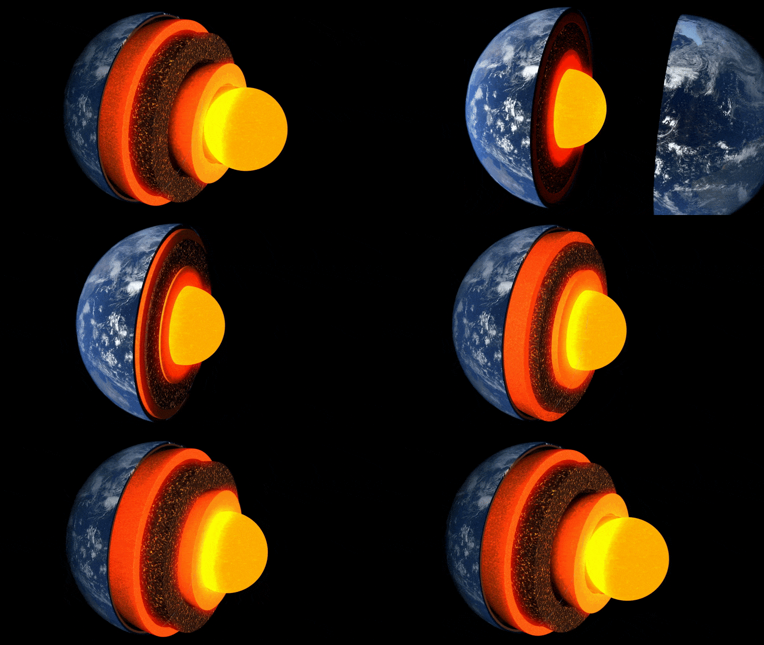
Κινούμενα σχέδια των στρωμάτων της γης.
Νέα έρευνα με επικεφαλής το Πανεπιστήμιο του Κέιμπριτζ είναι η πρώτη που έλαβε μια λεπτομερή «εικόνα» ενός ασυνήθιστου θύλακα βράχου στο οριακό στρώμα με τον πυρήνα της Γης, περίπου τρεις χιλιάδες χιλιόμετρα κάτω από την επιφάνεια.
Η μυστηριώδης περιοχή του βράχου, που βρίσκεται σχεδόν ακριβώς κάτω από τα νησιά της Χαβάης, είναι μια από τις πολλές περιοχές με πολύ χαμηλή ταχύτητα – ονομάζεται έτσι επειδή τα κύματα σεισμού αργούν να σέρνονται καθώς περνούν μέσα από αυτά.
Έρευνα που δημοσιεύτηκε στο περιοδικό στις 19 Μαΐου 2022 Επικοινωνίες για τη φύσηείναι το πρώτο που αποκαλύπτει λεπτομερώς την περίπλοκη εσωτερική ασυμμετρία ενός από αυτούς τους θύλακες, ρίχνοντας φως στα βαθιά εσωτερικά τοπία της Γης και τις διαδικασίες που λειτουργούν μέσα σε αυτά.
«Από όλα τα βαθιά εσωτερικά χαρακτηριστικά της Γης, αυτό είναι το πιο υπέροχο και πολύπλοκο». – σαν εμένα
“Από όλα τα βαθιά εσωτερικά χαρακτηριστικά της Γης, αυτό είναι το πιο συναρπαστικό και πολύπλοκο. Έχουμε τώρα τα πρώτα στέρεα στοιχεία που δείχνουν την εσωτερική της δομή – είναι ένα πραγματικό ορόσημο στη βαθιά σεισμολογία”, δήλωσε ο επικεφαλής συγγραφέας Zhi Li, φοιτητής διδάκτορα. στο Τμήμα Επιστημών της Γης στο Cambridge. έδαφος».
Το εσωτερικό της Γης σχηματίζεται σαν κρεμμύδι: στο κέντρο είναι ο πυρήνας σιδήρου-νικελίου, που περιβάλλεται από ένα παχύ στρώμα γνωστό ως μανδύας, και πάνω από αυτό ένας λεπτός εξωτερικός φλοιός – ο φλοιός στον οποίο ζούμε. Αν και ο μανδύας είναι συμπαγής βράχος, είναι αρκετά ζεστός ώστε να ρέει πολύ αργά. Τα εσωτερικά ρεύματα μεταφοράς τροφοδοτούν θερμότητα στην επιφάνεια, προκαλώντας κίνηση των τεκτονικών πλακών και τροφοδοτώντας ηφαιστειακές εκρήξεις.
Οι επιστήμονες χρησιμοποιούν σεισμικά κύματα από σεισμούς για να «δουν» τι βρίσκεται κάτω από την επιφάνεια της Γης – οι ηχώ και οι σκιές αυτών των κυμάτων αποκαλύπτουν εικόνες που μοιάζουν με ραντάρ από το βαθύ εσωτερικό. Αλλά μέχρι πρόσφατα, οι «εικόνες» δομών στο όριο πυρήνα-μανδύα, μια περιοχή πρωταρχικού ενδιαφέροντος για τη μελέτη της εσωτερικής ροής θερμότητας του πλανήτη μας, ήταν κοκκώδεις και δύσκολο να ερμηνευθούν.

Τα γεγονότα και οι τροχιές των ακτίνων Sdiff που χρησιμοποιήθηκαν σε αυτή τη μελέτη. α) Μια διατομή που διασχίζει το κέντρο της περιοχής εξαιρετικά χαμηλής ταχύτητας στη Χαβάη, που δείχνει τροχιές ακτίνων για κύματα Sdiff στις 96°, 100°, 110° και 120° για το μοντέλο 1D PREM Earth. Οι διακεκομμένες γραμμές από πάνω προς τα κάτω δείχνουν τις ασυνέχειες των 410 km, 660 km και 2.791 km (100 km πάνω από το όριο πυρήνα-μανδύα). β) Γεγονότα και τροχιές ακτίνων Sdiff στο μοντέλο τομογραφίας υποβάθρου SEMUCB_WM1 σε βάθος 2791 km. Μπάλες παραλίας για εκδηλώσεις βαμμένες σε διαφορετικά χρώματα, συμπεριλαμβανομένων 20100.320 (κίτρινο), 20111214 (πράσινο), 20120417 (κόκκινο), 20180910 (μωβ), 20180518 (καφέ), 20181030 (ροζ), 20111214 (πράσινο), 20180910 (μωβ), 20180518 (καφέ), 20181030 (ροζ), 2016 (201611) , και ακτίνες. Τροχιές κυμάτων Sdiff σε βάθος τρύπας 2791 km στον κάτω μανδύα που χρησιμοποιήθηκαν σε αυτή τη μελέτη. Το συμβάν που χρησιμοποιείται στην ανάλυση σύντομης περιόδου επισημαίνεται με κίτρινο χρώμα. Η προτεινόμενη θέση ULVZ εμφανίζεται σε μαύρο κύκλο. Η διακεκομμένη γραμμή δείχνει τη διατομή που σχεδιάστηκε στο A. Credit: Nature Communications, DOI: 10.1038/s41467-022-30502-5
Οι ερευνητές χρησιμοποίησαν υπερσύγχρονες μεθόδους αριθμητικής μοντελοποίησης για να ανιχνεύσουν δομές χιλιομετρικής κλίμακας στο όριο πυρήνα-μανδύα. Σύμφωνα με τον συν-συγγραφέα Δρ. Kuangdai Leng, ο οποίος ανέπτυξε τις μεθόδους ενώ βρισκόταν[{” attribute=””>University of Oxford, “We are really pushing the limits of modern high-performance computing for elastodynamic simulations, taking advantage of wave symmetries unnoticed or unused before.” Leng, who is currently based at the Science and Technology Facilities Council, says that this means they can improve the resolution of the images by an order of magnitude compared to previous work.
The researchers observed a 40% reduction in the speed of seismic waves traveling at the base of the ultra-low velocity zone beneath Hawaii. This supports existing proposals that the zone contains much more iron than the surrounding rocks – meaning it is denser and more sluggish. “It’s possible that this iron-rich material is a remnant of ancient rocks from Earth’s early history or even that iron might be leaking from the core by an unknown means,” said project lead Dr Sanne Cottaar from Cambridge Earth Sciences.

Conceptual cartoons of the Hawaiian ultra-low velocity zone (ULVZ) structure. A) ULVZ on the core–mantle boundary at the base of the Hawaiian plume (height is not to scale). B) a zoom in of the modeled ULVZ structure, showing interpreted trapped postcursor waves (note that the waves analyzed have horizontal displacement). Credit: Nature Communications, DOI: 10.1038/s41467-022-30502-5
The research could also help scientists understand what sits beneath and gives rise to volcanic chains like the Hawaiian Islands. Scientists have started to notice a correlation between the location of the descriptively-named hotspot volcanoes, which include Hawaii and Iceland, and the ultra-low velocity zones at the base of the mantle. The origin of hotspot volcanoes has been debated, but the most popular theory suggests that plume-like structures bring hot mantle material all the way from the core-mantle boundary to the surface.
With images of the ultra-low velocity zone beneath Hawaii now in hand, the team can also gather rare physical evidence from what is likely the root of the plume feeding Hawaii. Their observation of dense, iron-rich rock beneath Hawaii would support surface observations. “Basalts erupting from Hawaii have anomalous isotope signatures which could either point to either an early-Earth origin or core leaking, it means some of this dense material piled up at the base must be dragged to the surface,” said Cottaar.
More of the core-mantle boundary now needs to be imaged to understand if all surface hotspots have a pocket of dense material at the base. Where and how the core-mantle boundary can be targeted does depend on where earthquakes occur, and where seismometers are installed to record the waves.
The team’s observations add to a growing body of evidence that Earth’s deep interior is just as variable as its surface. “These low-velocity zones are one of the most intricate features we see at extreme depths – if we expand our search, we are likely to see ever-increasing levels of complexity, both structural and chemical, at the core-mantle boundary,” said Li.
They now plan to apply their techniques to enhance the resolution of imaging of other pockets at the core-mantle boundary, as well as mapping new zones. Eventually, they hope to map the geological landscape across the core-mantle boundary and understand its relationship with the dynamics and evolutionary history of our planet.
Reference: “Kilometer-scale structure on the core–mantle boundary near Hawaii” by Zhi Li, Kuangdai Leng, Jennifer Jenkins and Sanne Cottaar, 19 May 2022, Nature Communications.
DOI: 10.1038/s41467-022-30502-5

“Ερασιτέχνης διοργανωτής. Εξαιρετικά ταπεινός web maven. Ειδικός κοινωνικών μέσων Wannabe. Δημιουργός. Thinker.”

